


Facing Mount Daisen's South Face at Kagikake Pass
The appeal of Kagikake Pass (Kagikake-tōge) is not simply a view of the summit, but the chance to take in the depth of Mount Daisen's south face, where rock and forest overlap.
From the viewpoint on the Kōfu town side, at an elevation of about 910 m, shift your gaze from the beech forest in front of you to the south face rising beyond it to see the contrast between volcanic terrain and lush vegetation.
Why View the South Face Head-On?
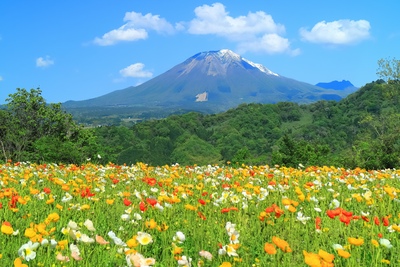
Mount Daisen changes appearance depending on the direction from which you view it; from the south, a long expanse of rock shaped by collapses makes a striking impression.
At Kagikake Pass, the broad view of this rugged outline lets you observe not just the mountain's height, but also its successive slopes and the shadows along its gullies.
Although you are looking at a mountain in the distance, the same view invites you to imagine both the time that has worn away the terrain and the time over which forest has covered its slopes—an experience distinctive to this pass.
Move Your Gaze from Foreground to Background
Look first at the nearby trees, then at the beech forest in the middle distance, and finally at the south face to appreciate a sense of distance that photographs alone may not convey.
The first step to enjoying Kagikake Pass's distinctive scenery is to see the forest and rocky areas as separate layers, rather than treating the landscape as a single flat image.
Why Does Mount Daisen Look Different from Each Side?
Mount Daisen's andesite slopes are prone to collapse, and rock walls formed by these collapses extend along its southern and northern sides.
Because the ridgelines and exposed rock of the same mountain look different depending on your viewing direction, the south face seen from Kagikake Pass offers an introduction to Daisen's varied terrain.


The Contrast Between Beech Forest and Rock at Kagikake Pass
The scenery at Kagikake Pass is defined neither by its grayish rock walls alone nor by its forests of green or autumn foliage alone.
Seeing the hard south face and the soft tree canopy together emphasizes the contrasting qualities of Daisen's natural landscape.
One of Western Japan's Largest Beech Forests
Mount Daisen is covered by what is considered one of western Japan's largest beech forests, and Kagikake Pass lets you see the forest spreading across the slopes as a vast whole.
Rather than picking out individual trees, observe how the canopy's color and density change with elevation to see how the forest shapes the mountain's outline.
Divide the Landscape into 3 Layers
The following table offers a way to organize your view from the lookout.
| Viewing Distance | Main Elements | What to Notice |
|---|---|---|
| Foreground | Trees and open space | The framing effect |
| Middle distance | Beech forest | Color and density |
| Background | Mount Daisen's south face | Ridgelines and gullies |
Observing in this order makes it easier to understand the overall structure of the landscape from Kagikake Pass than simply zooming in on the distance.
Your eyes can take in a broader view than a photograph, so slowly look left and right to compare where the forest's height and the gaps in the rock walls change.
Light and Shadow Shaped by the Weather
On days with moving clouds, light and shadow alternate across the south face, sometimes making the gullies and contours of the rock stand out more strongly.
Even when clouds hide the summit, you can enjoy a scene unique to that moment by focusing on the boundary between forest and rock or on the lower slopes.


How Kagikake Pass's Scenery Changes with the Seasons
Fresh greenery from spring into summer and autumn foliage are signature sights at Kagikake Pass, where the forest's colors change dramatically within the same composition.
However, foliage color and visibility depend on the weather, so it is important to check the latest local information before visiting rather than assuming a particular date will be ideal.
Fresh Greenery Highlights the South Face's Outline
As new leaves emerge and deepen in color, the difference between the bright forest and the exposed rock becomes especially clear.
Look beyond vivid colors to the green spreading along the slopes, and you can sense the scale of the beech forest.
Strong sunlight creates finely divided patches of light and shade among the leaves, while overcast skies make the forest's color appear more unified; these weather differences can be appreciated as part of the scenery's character.
Autumn Foliage Is More Than a Single Color
In autumn, reds and yellows overlap with evergreen tones, bare branches after leaf fall, and the gray of the south face, creating subtle layers of color.
Because foliage conditions change with timing and weather, the latest autumn-color reports are a more reliable guide to choosing a visit date than fixed peak-season information.
Even after many leaves have fallen, there are other ways to enjoy the view, such as seeing the slopes more clearly through the branches; recognizing value beyond peak color allows for a more relaxed trip.


Photography at Kagikake Pass: Composition and Consideration
Kagikake Pass is a well-known photography spot, but capturing the scenery needs to go hand in hand with allowing others to enjoy the view safely.
Keep the Forest in Wide-Angle Shots
Filling the frame with the south face alone creates a powerful image, but weakens the contrast with the beech forest that makes Kagikake Pass distinctive.
Keep a suitable amount of foreground and middle distance in the frame, adjusting the proportions of sky, rock wall, and forest to find a composition that reflects the depth you felt.
Look for Patterns on the Slopes with a Telephoto Lens
When isolating a scene with a telephoto lens, look beyond a single point on the ridgeline to shadows in the gullies and the boundary where forest gives way to rock to convey the terrain's character.
Even while waiting for a break in the clouds or a shift in the light, choose a position that does not block passage or other visitors' views.
Adapt Your Approach to the Conditions
The following table helps you choose a photography approach suited to conditions on-site.
| Conditions | Suitable Approach | What to Keep in Mind |
|---|---|---|
| Clear skies | A broad composition | Contrast with the forest |
| Heavy cloud cover | Frame a detail | Light and shadow |
| Crowded | Take photos promptly | Make room for others |
| Poor visibility | Do not insist on waiting | Put safety first |
Avoid occupying a spot for a long time with a tripod or other equipment, and do not step carelessly toward the road; these are basic ways to share a scenic location considerately.
After taking a photo, avoid continuing to look only at your screen. Check your footing and the movement around you before stepping away so visitors can make room for one another even in the limited viewing space.


Getting to Kagikake Pass: Parking and Restrooms
Kagikake Pass lies on a driving route around Mount Daisen, making it easier to plan a visit by car than to reach it directly using public transport alone.
The Daisen Parkway is a driving route from the Hiruzen Highlands (Hiruzen Kōgen) through Kagikake Pass to Mihonoseki, passing through one of western Japan's largest beech forests.
Weather and road conditions in the mountains differ from those on the plains, so include a check before departure in your plans.
Set a Precise Destination
Kagikake Pass is located at 1531-29 Aza Kagikake, Ōaza Ōkawara, Kōfu-chō.
By car, Kagikake Pass is about 50 minutes from Yonago Airport and about 35 minutes from Yonago Station.
Enter the address accurately in your car's navigation system rather than choosing a destination solely because a search result has a similar name.
Check Parking and Restroom Facilities
There are 15 free parking spaces, and restrooms are also available.
This standard facility information is useful for planning, but the area can get crowded during autumn foliage season and at other busy times, so prioritize on-site directions and the day's road guidance.
Allow for sudden weather changes in the mountains. If visibility is poor or you are unsure about the road surface, do not cling to your plans; make the safer choice, including turning back.
If you expect to spend a long time standing and enjoying the view, account for how conditions may feel different from those on the plains and bring clothing suited to the temperature so you can observe the scenery comfortably.

Combine Kagikake Pass with Nearby Nature
Rather than ending your itinerary at Kagikake Pass, link it with forests and highlands on Daisen's southern side to understand the nature seen from the viewpoint at a different distance.
Step Inside the Forest at Kitanizawa Stream
Kitanizawa Stream (Kitanizawa Keiryū) is about a 5-minute drive from Kagikake Pass. There, you can hear flowing water and birdsong within the forest.
At the stream, the beech forest you saw from afar at Kagikake Pass becomes a close-up environment, so combining the 2 places deepens your understanding of the landscape.
Compare the View Toward the Masumizu Highlands
Other nearby viewpoints, including the Masumizu Highlands (Masumizu Kōgen), offer different viewing directions and foregrounds even though the mountain is the same Daisen.
Rather than visiting as many spots as possible, compare what you can see from each direction to form a three-dimensional memory of Daisen's terrain.
Making the Most of Kagikake Pass's Scenery
At Kagikake Pass, take in the contrast between Daisen's rugged south face and one of western Japan's largest beech forests in the order of foreground, middle distance, and background to appreciate its depth.
Enjoy the seasonal colors and changing weather, check the latest road and local information before visiting, and be considerate of others when taking photos so you can enjoy the landscape safely.




Reviews (0)