


Plan Your Mount Yamainu Hike Around Your Interests and Fitness
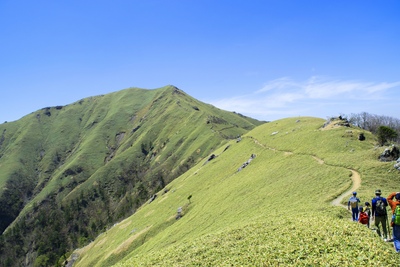
Mount Yamainu (Yamainu-dake) in Kamikatsu, Tokushima Prefecture, is well known within the prefecture for its forest landscape of huge moss-covered boulders.
Before visiting Mount Yamainu, decide how far you want to walk as well as what scenery you hope to see.
Allowing separate time for walking, enjoying nature, and resting makes it easier to put together a manageable itinerary.
How Mount Yamainu's Moss-Covered Boulders Were Formed
Mount Yamainu rises to 997.6 m, and its name is said to come from a rock at the summit that resembled a mountain dog with its mouth open before the mountain collapsed.
In 1701, the 14th year of the Genroku era, heavy rain caused much of the mountain to collapse, creating today's landscape of numerous boulders around 10 m high.
The abundance of enormous rocks made it a sacred site for Shugendō, a tradition of mountain ascetic practice, and it has also been revered for its association with Kūkai, the founder of Shingon Buddhism, and as a place to pray for rain.
Along the hiking trail are 88 small stone Buddhist statues modeled on the Shikoku 88 Temple Pilgrimage, while the route toward the summit also passes Tōkō-ji Temple, with views extending to the Pacific Ocean, and Kumosa Shrine, dedicated to the rain deity.
Choose Between the Moss Viewpoint and the Summit
If your aim is to observe nature, identify the places you want to see and choose a walking route that suits that purpose.
The thickly moss-covered rocks are found around the moss viewpoint, known as Koke no Meisho, about 40 minutes into the forest from the trailhead.
If you plan to reach the summit, check your descent route in advance as well as the way to your destination.
Even if you have seen beautiful photographs, check the condition of the trail separately and decide whether the route suits your hiking experience.
Distances and Hiking Times to the Moss Viewpoint, Tōkō-ji, and the Summit
Approximate distances and walking times from the trailhead are listed below.
| Destination | Distance from the Trailhead | Approximate Walking Time (One Way) |
|---|---|---|
| Moss viewpoint | 950 m | About 40 minutes |
| Tōkō-ji | 1,420 m | About 60 minutes |
| Mount Yamainu summit | 1,740 m | About 75 minutes |
The parking area is also about 2 km, or a 30-minute walk, from the trailhead, so include that round trip in your itinerary.
If you are climbing to the summit, allow plenty of time for the descent, breaks, and photography.
Agree on a Walking Pace with Your Companions
When hiking in a group, set your pace to suit the least experienced walker and agree on breaks and when to turn back.
Let others know when you stop so that those taking photographs do not become separated from those who want to keep walking.
Consider fatigue from your travels, avoid packing too much into the rest of the day, and leave room to shorten the hike depending on how you feel.


Best Time to Visit Mount Yamainu: Moss Season and Weather
It is important both to research the best time to see the scenery and to assess whether the trails are suitable for walking on the day you visit.
Check the weather forecast and local guidance before setting out, rather than choosing your clothing and route based only on the season's general character.
Check What Seasonal Moss and Fall Foliage Information Refers To
When reading seasonal descriptions, check which plants or landscapes they describe.
Mount Yamainu's moss can be seen year-round, but it is at its richest green and most moist from the June rainy season into early summer.
The area around Tōkō-ji, by contrast, is especially recommended during the fall foliage season, when red and yellow maples mix with green Japanese cedars.
Natural scenery changes with the weather, so the colors and lighting you have seen in photographs may not look exactly the same during your visit.
Keeping an open mind about the scenery and adapting your walking route and observations to the day's conditions makes it easier to avoid pushing yourself too far.
Reconsider Your Plans if Rain or Poor Visibility Is a Concern
On rain-soaked mountain trails, take care not to slip on rocks, tree roots, and other surfaces.
Remember that the rainy season and the hours after rain, when the moss looks particularly fresh, can also make the ground especially slippery.
Even if you are eager to photograph the scenery, do not press on in severe weather or poor visibility.
Having an alternative plan if you skip the hike makes it easier to decide based on the day's conditions without feeling tied to reservations or your travel schedule.

Follow Maps and Local Guidance on Mount Yamainu's Hiking Trails
Research your route in advance and follow local guidance and access restrictions when hiking here.
Leaving the hiking trail or continuing beyond the summit can put you at risk of getting lost.
Keep checking the ground and your surroundings rather than walking with your eyes fixed on your smartphone.
Check Both Your Outbound and Return Routes at Junctions
At a junction, use your map to confirm the destination name and direction, and note which path you will take on the way back.
Signs on Mount Yamainu are in Japanese, so it is helpful to collect a map from the box at the trailhead or walk with a guide.
If you are unsure about reading Japanese signs, saving the Japanese spellings of your destination and starting point can help you match them.
For example, keeping a record of the Japanese labels for the moss viewpoint, Tōkō-ji, and the summit makes it easier to compare them with signs at junctions.
Do not continue without understanding the guidance; prepare so that you can resolve any questions before setting out.
Return the Way You Came Instead of Continuing Beyond the Summit
Even if you feel like continuing after reaching your planned destination, reassess your remaining energy, the weather, and your return transportation plans.
The path beyond Mount Yamainu's summit is extremely dangerous because it is not maintained and has no direction signs.
Once you reach the summit, do not continue farther; descend by retracing your steps.
A line shown in a map app does not necessarily mean that a route is safe to use.
Stay on the route you have checked, and do not take shortcuts or paths whose accessibility is uncertain.
Plan to Finish Your Descent Before Dark
Think beyond your arrival time at the destination to when you will finish descending and connect with your onward transportation.
Plan to be off the mountain while it is still light, as walking after dark is dangerous.
If breaks or photography take extra time, adjust the rest of your plans accordingly.
If you feel you are falling behind schedule, turn back while you still have time to spare rather than insisting on reaching your destination.


How to Get to Mount Yamainu: Plan Parking and Your Return Journey
Do more than enter the mountain's name into a map app: confirm where your walk begins and how you will get there.
Mount Yamainu's trailhead is northeast of the Kashihara rice terraces in Kamikatsu.
The area, which consists of the rice terraces and 3 settlements, has been designated a national Important Cultural Landscape under the name Kashihara Rice Terraces and Rural Landscape.
Use the Parking Area Before the Trailhead if Driving
If driving, consult official guidance for available parking and the approach route, and include the journey from the parking area to the start of your hike in your plans.
There is no dedicated parking at the trailhead, so park about 2 km before it and walk for approximately 30 minutes to reach the trailhead.
The drive from Tokushima Station to the parking area takes about 1 hour 30 minutes and covers roughly 40 km.
Many roads in Kamikatsu are narrow and steep, so drive with particular care.
An empty lot or open space beside the road is not necessarily a place where parking is allowed.
Follow local signs, avoid entering residential properties or fields without permission, and do not park where you would block the road.
The area around the trailhead is privately owned, and ambulances, fire engines, and other emergency vehicles may need to use the road.
Check Operating Days and Connections for Public Transportation
If combining public transportation services, research possible routes and check official transport information for operating days, connections, and how to continue after getting off.
It is important to plan not just your outbound service, but also where you will return after the hike and how you will get back to your accommodation.
If considering a pickup service or taxi, check availability and the meeting point in advance.
Kamikatsu's only taxi company closed in 2002, and local transportation is now supported by services such as a reservation-based paid volunteer taxi scheme.
Do not assume you can call a taxi once you arrive; check available pickup services and booking procedures before setting out.
Use Restrooms and Buy Supplies Before Heading to the Trailhead
Check restroom locations and places to buy drinks before leaving, rather than assuming they are available at the trailhead.
Visitors to Mount Yamainu can use the restrooms at Kamikatsu Town Hall, whose entrance is open on Saturdays, Sundays, and public holidays as well.
Restrooms in the settlement cannot accommodate large groups, and you should also avoid asking nearby residents to use the toilets in their homes.
Build available facilities into your route and finish your preparations and essential shopping before heading into the mountain.


What to Wear and Pack for a Mount Yamainu Hike
Even if your main goal is nature observation or photography, prepare footwear and weather protection suitable for mountain walking.
Choose Comfortable Hiking Shoes and Easy-to-Adjust Layers
Choose well-fitting shoes with nonslip soles and pack your belongings in a bag you can carry on your back to keep both hands free.
Parts of the trail toward the summit are steep, so trekking shoes or hiking boots with deep tread are a sensible choice.
Choose clothing that allows freedom of movement and easy temperature control, combining layers you can adjust when you warm up while walking or cool down during breaks.
With the summit at 997.6 m, adding a warm layer suited to the season and temperature makes it easier to avoid getting cold while resting.
Thinking about when you will use each item on the trail can help you decide what to pack.
| Situation | Suggested Items | What to Look For |
|---|---|---|
| Rain | Rain gear | Keeps both hands free |
| Cool temperatures | Layered clothing | Easy to put on and remove |
| Refueling during breaks | Drinks and trail snacks | Easy to reach |
| Checking the route | A saved map | Readable without a connection |
Prepare Maps and a Communication Plan for Areas Without Cell Reception
Some parts of Mount Yamainu have no cell phone reception.
Save maps and essential guidance in advance so that you can read them even without an internet connection.
Fully charge your smartphone and consider carrying a backup power source.
Tell your accommodation or family where you are going and when you expect to return, and be prepared for situations where online translation and phone calls are unavailable.

How to Observe and Photograph Mount Yamainu's Moss Without Damaging It
Enjoy the scenery as it is, from places where walking is permitted, and make that your guiding approach.
Even if you find moss or small plants you want to photograph, do not step off the path to approach them or pick them for a picture.
Do not step on moss, peel it off, or take it home.
Avoid climbing onto moss-covered rocks to take photographs or touching the moss to feel its texture.
Compose Your Photographs from the Trail Rather Than Moving Closer
To capture small subjects in detail, adjust your camera angle or zoom from a safe position on the hiking trail.
Before taking a photograph, check your footing and the movement of people around you instead of stepping backward while looking at your screen.
Choose a way to photograph each subject that does not disturb nature or obstruct the trail.
| Subject | How to Enjoy It | What to Avoid |
|---|---|---|
| Fine details of the moss | Zoom in from the trail | Stepping onto the moss |
| Depth of the forest | Include trees in the composition | Leaving the trail to move closer |
| Small plants | Photograph them as they are | Picking and rearranging them |
| Photos of your companions | Keep the path clear | Blocking the trail for a long time |
Take Your Trash Home and Check Your Belongings After Breaks
Choose a resting place where other people can pass, and take care not to damage plants when putting down your bags.
Everyone should take their own trash home.
Before leaving, check for lost belongings as well as any remaining litter.
- Take food wrappers and drink containers home
- Keep bags and small belongings from blowing away
- Avoid loud noises and respect others quietly observing nature
Mount Yamainu Hiking Tips to Remember
Start planning your hike among Mount Yamainu's moss-covered boulders by choosing your destination and walking distance, arranging round-trip transportation, and preparing suitable gear.
Adjust your itinerary to the day's weather and local guidance, do not continue beyond the summit, and give equal importance to enjoying the scenery and returning safely.
Observing and photographing from the trail without altering nature helps protect Mount Yamainu's moss and landscape.


Reviews (0)